TL;DR
Free tools like QGIS and open UK datasets let small businesses map customers and operations without a licence cost, as shown by a Chelmsford plumbing firm that used drive-time analysis to cut fuel spend.
Why GIS matters for smaller organisations
In anticipation of GIS Day, we wanted to shine a spotlight on how Geographic Information Systems (GIS) can be used both technically and strategically to help small and medium-sized enterprises (SMEs) make informed strategic decisions to aid growth.
GIS is a method of understanding how patterns in place and time influence business performance. For small organisations where every resource counts, visualising where customers, assets and risks are located can reveal efficiencies and opportunities that are not obvious in spreadsheets.
What keeps smaller players out?
GIS is often perceived as an expensive, highly technical tool that is only useful for large infrastructure projects or multinational corporations. However, this assumption overlooks an important truth: insight derived from GIS can be just as valuable for smaller organisations, and it is much more accessible than many believe. Most people interact with some form of GIS every day — looking at traffic on Google Maps, or tracking an Amazon parcel.
By dismissing GIS as something out of reach, SMEs risk losing out on practical ways to visualise their data.
Cost of Software and Data
Commercial GIS licences can cost thousands of pounds per year, creating a perception that mapping is only for major projects.
Platform Complexity
The technical setup and specialist language can feel daunting for those new to GIS. GIS as a discipline takes time to learn, and many tutorials are aimed at academic or large-scale applications rather than small business needs. For busy teams, it can feel unrealistic to dedicate days to learning new software when their focus is on operations.
Skills Gap
Small organisations rarely have a dedicated GIS resource, making it harder to get started.
Time Pressures
In small businesses, staff often wear multiple hats, and mapping can easily be deprioritised against day-to-day operations.
Uncertain Return on Investment
Without clear examples of success, it can be difficult to justify spending time and effort on GIS tools.
Bridging the Gap: Emerging opportunities
The good news is that the barriers to entry are lower than ever:
Open Data Availability
The UK is a world leader in open geospatial data, including Ordnance Survey base maps, Environment Agency flood data, and a wide variety of information published by local authorities. This is readily available in open data portals, such as data.gov.uk.
Free and Open-Source Tools
Tools like QGIS and OpenStreetMap allow SMEs to produce professional, data-driven maps without expensive licences. Our Knowledge Hub has more on choosing the right GIS tools for your situation.
Accessible Support and Training
More consultancies and training providers are now focusing on smaller organisations, providing affordable, hands-on support that helps teams use GIS independently.
Three free datasets worth knowing
Before building anything, it helps to know what is actually available without paying for a licence. Three sources cover most small business use cases.
OS Open Data from Ordnance Survey includes OpenMap Local (buildings, roads, land use), Open Roads, and Boundary-Line (administrative boundaries down to ward level). All of it is free to use, including commercially, and updated regularly. For any business that needs to understand where its customers or sites sit relative to roads, postcodes, or administrative areas, this is the starting point.
ONS geography and Census data provides population, household, and demographic statistics down to small area level (Output Areas, typically a few hundred people). A retail or hospitality business trying to understand its catchment area can combine this with drive-time analysis to see not just who is nearby, but what the local population actually looks like.
Environment Agency flood and environmental data matters for any business assessing physical risk to premises or assets, not just developers. A small business considering a second site, or renewing insurance, can check flood risk and environmental designations for free rather than relying on a broker’s summary.
An example in action: plumbing service
In this example, we are keen to show that even when using the most basic functionality of mapping software, we can begin unpicking the patterns in our data.
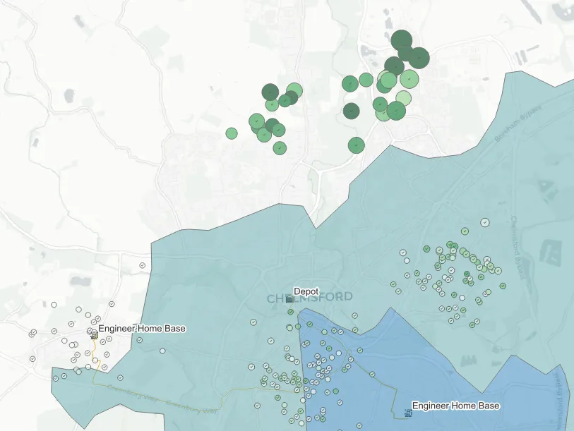
A small plumbing service based in Chelmsford collected data on their callouts over the past year. They are looking to reduce their drive time and CO₂ emissions, in turn reducing their fuel expenditure.
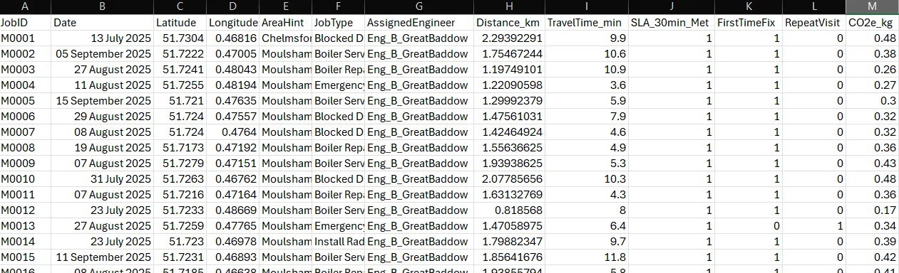
In this form, they were unable to draw any insights from the data despite it containing information that can be used to create a map. As the data is inherently geographic, they decided to plot this information using QGIS (a free open source resource).
This step alone became valuable to the company. The map revealed clusters of jobs in Moulsham and Chelmer Village, both within easy reach of existing engineers, but also a growing concentration of calls to a new development in Beaulieu Park. These calls consistently took longer to reach, costing more fuel.
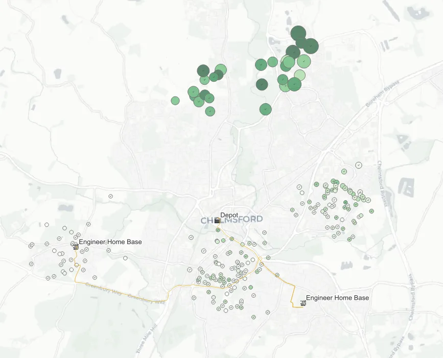
The map was then enriched with drive time isochrones, identifying that the cluster of new jobs from the Beaulieu Park area fall outside of a typical 10-minute journey from their home bases/depot.
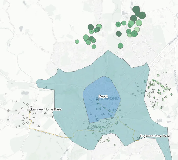
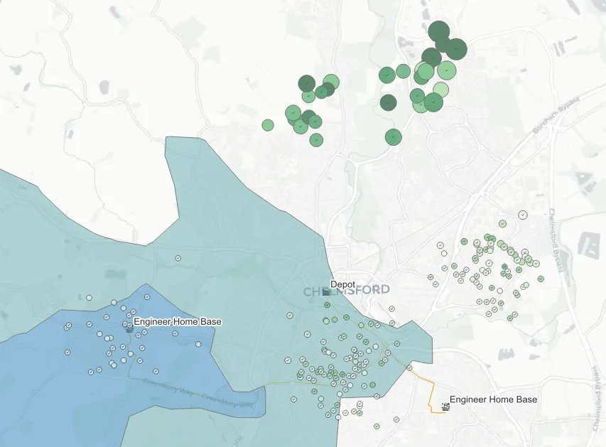
At this point, the company has a strategic decision to make. They can:
-
Rebase or reposition an engineer: Instead of every van returning to the same depot each night, one vehicle could be left overnight at a partner site, rented parking spot, or a secure lockup. The engineer starts their day by driving directly to the job, immediately reducing unnecessary travel time.
-
Implement a satellite van stock point: The engineer restocks locally instead of returning to the main depot, saving on unnecessary round trips and maintaining productivity throughout the day.
-
Part time contractor in the area: If a full rebase cannot be justified, the company can instead subcontract or hire a part-time technician to cover the patch. This offers flexible coverage without the commitment of a full relocation.
-
Change job allocation routes and policy: GIS can provide the flexibility to speak with other systems seamlessly if configured correctly — integrating map analysis into the booking system can allocate the closest engineer rather than the first available. Scheduling could be adjusted so that one engineer handles all northern calls in a week, with their calendar being front-loaded with work in that area to reduce idle time. Both approaches allow the business to use its existing workforce more intelligently, directing engineers to the areas needed the most.
Together, these approaches demonstrate how even a simple spatial mapping exercise can inform a coherent strategy that is all backed by their own data.
A second example: understanding a customer catchment
The plumbing example is about operations. A different, equally common use case is understanding customers rather than routes.
Take an independent café weighing up a second location. Loyalty scheme sign-ups or card payment postcodes (most point-of-sale systems can export this) give a rough picture of where existing customers live. Plotted in QGIS against ONS Census data for the surrounding area, that customer list turns into a catchment map: where the current customer base actually clusters, and how far people are travelling for a coffee versus how far the average person in that area typically travels for similar spending categories.
That catchment map does two things a spreadsheet of postcodes cannot. It shows visually whether a candidate second site sits inside, at the edge of, or entirely outside the existing customer catchment, which matters enormously for whether that second site will cannibalise the first location’s trade or reach genuinely new customers. And it lets the business overlay footfall data or competitor locations (also open data in many town centres) to sense-check the decision before signing a lease, rather than after.
None of this requires a data team. It requires an afternoon in QGIS, a card payment export, and a willingness to look at the business spatially rather than as a single point on a map.
Getting started, practically
For a small business with no GIS experience, the realistic starting point is not a training course. It is one concrete question worth answering: where are my customers, my jobs, or my risks actually located, and does that match what I assumed?
Export whatever location data already exists (customer postcodes, job addresses, delivery points) into a spreadsheet. Install QGIS, which is free. Import the spreadsheet as a point layer using postcode or address lookup. At that point, the patterns the plumbing company and the café both found are usually visible within the first hour, before any formal analysis has been done at all. The value of GIS for a small business is rarely in the sophistication of the analysis. It is in seeing the data spatially for the first time.
Conclusion
For small organisations, GIS is not just a technical platform but a way of thinking spatially. It helps reveal how geography shapes customers, operations, and strategy.
A plumbing company can use GIS to reduce response times and emissions, while a café can better understand where its customers come from and whether a second site would reach new trade or simply split the first. In both cases, the principle is the same: spatial thinking leads to smarter, evidence-based decisions.
As data becomes more open and tools more accessible, GIS is no longer out of reach. For small businesses, now is the time to explore how location intelligence can guide growth and efficiency.
If you’re curious about what GIS could do for your organisation, take a look at our case studies — including a site selection app built in three weeks and a GIS data review for a national property consultancy — or get in touch for a free consultation.